Monday, May 30, 2016

Cannonville, UT - Cottonwood Canyon Rd

We decided to stay closer to the RV park today and chose to drive to Cannonville and search for the Grosvenor Arch.  It is located a number of miles past Kodachrome State Park.  The paved highway ends at Kodachrome SP and it's dirt road after that.  There are a number of warning signs stating 4x4 wheel drive vehicles should be used on the road and how impassible it is when it's wet.  It was a very dry day so we continued on our merry way.

The scenery was spectacular with grand vistas, steep canyons and tall cliffs.  The drive started off on RT 12 until we got to Cannonville and then we headed south.


Doesn't look too bad.


Hmmm!


And then this is what we had ahead of us.


Slot canyon


 The Grosvenor Arch was a mile or two off the road and there was a geocache there.

Grosvenor Arch is actually two sandstone arches towering 150ft/45m above the ground located in the north western corner of the Grand Staircase Escalante National Monument. The largest arch is nearly 100ft/30m in diameter. You can walk right up under the arches and look up into the sky. To get to the arch requires a short walk, on a concrete sidewalk, from the parking lot. There are pit toilet restrooms available.

Driving Directions
Take state route 12 south of Cannonville for approximately 9 miles. This is a paved road to the Kodachrome State Park turnoff. Continue on Cottonwood Canyon Road, a graded dirt road, for another 10 miles to the Grosvenor Arch parking lot. Cottonwood Canyon Road continues through the Grand Staircase Escalante NM.

Note: The arch was named after Gilbert Hovey Grosvenor, president of the National Geographic Society - the first full time editor of National Geographic Magazine.
  

Gerry and Larry at the Arch

Mud hole on road
 After viewing the area, taking photos, etc., we continued along the dirt road for a while longer.  Debbie & Dale wanted to hike the slot canyon but we ran out of time and had to head back out of there.  By this time we were about 35 miles off a paved highway, with a lot of rough areas on the road.  It was beautiful back there, but nice to get back to civilization.

It was dinner time by then and we decided to go to a restaurant Debbie and Dale had tried earlier.  The Big Canyon  Pines restaurant was full, but we decided to wait for a table.  45 minutes later we were seated.  We commented about the number of foreign tourists there, but it is a holiday weekend.  We all enjoyed our food and conversation, but were all running out of steam, so headed straight back to the park from there.

That was our day, how was yours?

Saturday, May 28, 2016

Cedar Breaks Nat'l Monument & Mammoth Creek

May 27, 2016

I had read where the Cedar Breaks National Monument was going to open today after being closed all winter.  We (Gerry, Debbie, Dale and I) decided to drive up there and enjoy the views from 10,500ft.

First we explored a forest road and wound up at a beautiful area with Mammoth Creek running through it.  The creek was full of water from the snow melt above the area.  There were a number of campers along the creek with all their ATVs, kayaks and other playtoys.

Gerry and I along the creek


Debbie & Dale


Mammoth Creek


 The area around the creek was really wild with rough rock roads and was very steep in places.  It made us wish we still had our old Jeep so we could explore more in the area.  There were huge lava fields that were 30-40ft high and miles long.


We reluctantly left the area and headed for Cedar Breaks Nat'l Monument to check it out.  There was a considerable amount of snow in the area with the meadows covered in snow.


Cedar Breaks National Monument is a U.S. National Monument located in the U.S. state of Utah near Cedar City. Cedar Breaks is a natural amphitheater, stretching across 3 miles (4.8 km), with a depth of over 2,000 feet (610 m). The elevation of the rim of the amphitheater is over 10,000 feet (3,000 m) above sea level. The eroded rock of the amphitheater is more eroded than, but otherwise similar to formations at Bryce Canyon National Park, Red Canyon in Dixie National Forest and select areas of Cedar Mountain (SR-14). Because of its elevation, snow often makes parts of the park inaccessible to vehicles from October through May. Its rim visitor center is open from June through October. Several hundred thousand people visit the monument annually. The monument area is the headwaters of Mammoth Creek, a tributary of the Sevier River.


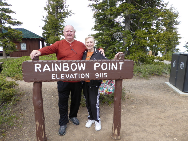
 I am standing on more than a foot of snow at the sign below.  It was breath taking in more than one way.   It was difficult breathing at that altitude since we weren't used to the thin air up there.


Debbie had me in her sights with a snowball but thankfully she missed me.  


The view from the overlook was beautiful and quite cold considering it was 2pm.  We snapped some pictures and decided to see what else was up there.


Gerry got a laugh out of this sign.  The campground was closed due to heavy snow in the area.  


At Brian Head ski area we saw this house on the top of the mountain.  We couldn't find a road up there or we would have checked it out.  This was a CCC project of years ago.  How would you like to live up there?


Long range view of the house on the mountain to give you a perspective how high up it was.


ATVers having fun in the creek


We drove down the mountain with 8% grades and 15 mph curves.  It was pretty along the way and it was difficult keeping my eye on the road.  I did notice a side road called "2nd Left Turn Canyon" and thought someone had a sense of humor giving the road that moniker.

The road lead up a canyon for a number of miles and we were on the ground floor looking up.  There were many fantastic views with multicolored rocks and large boulders.


 Shortly down the road we came across this creek covering the road.  It was only a foot or so deep so I drove through it hoping there wasn't a thunderstorm above the area.


Nice rock formation with an arch.


These rocks look like they are ready to roll down the hill
 There was a beautiful home along the road with a tennis court and a super setting.  They had this huge mountain lion near the gate to the home. 


Our next destination was the Parowan Gap to check out the petroglyphs there.  There are numerous etchings there that tell many stories of the Hopi Indians that lived there 1500 years ago. 


Notice the space ship design in the upper right side of the picture
 Do you think aliens were in the area many centuries ago?  It makes you wonder if they really were here.


It was getting late and we were a long way from our RV and still had dinner on our schedule.  Cedar City was close by and we picked the All American Grill for dinner.  It turned out to be a great selection and we enjoyed our meals.  They had Country Fried Steak on special for $5.99 and it was delicious.  We walked out of there with full stomachs and recommend it to anyone who is passing through the area.

We still had to drive over a mountain with 8% grades and tight curves to get back to the RV park.  Once again it was a scenic drive with a variety of cliffs, lava fields, mountain lakes, campgrounds.  

Finally, we arrived back home and were exhausted by all the walking and sight seeing.  Tired, but satisfied.

Our brother-in-law Tom M has a birthday on May 28 and we wish him a very Happy Birthday.

That's all for now.  Hope you all have a very nice Memorial Day weekend and celebrate the occasion with the reverence it deserves.

Byrce Canyon & Red Canyon, Utah

May 26, 2016

Memorial Day weekend is fast approaching and we decided to take a drive to Bryce Canyon to try and avoid the mob scene approaching.  The day started off poorly with lousy weather and we almost decided to call it off.  Thankfully, we didn't as it turned out to be a nice day.

We are only about 5 miles from Red Canyon and stopped there first.  There are two tunnels on the road and they photograph very well.  We waited as long as we could to avoid having vehicles in the photos.  Luck was on our side and we got the shots we wanted.


The red rocks are beautiful and sort of reminded us of the Sedona, AZ area.  There are numerous hiking trails in the area along with a great biking/hiking path that meanders along for miles.  


Gerry and I both like to get off the highway and take dirt forest roads to see what is out there.  In this case there was a geocache hidden in the rocks and Gerry "volunteered" to find it.  She is in the middle of the picture trying to stay warm and sign the cache log.  We continued down the road to the point where it got so rough that it was time to turn around.  If we would have had our old Jeep we could have continued more to the back country.


 Next stop on our agenda was to tour the Bryce Canyon Nat'l Park to enjoy it's beauty.  We wound up picking the right day since they weren't so busy that finding parking spaces was a chore. 


They say you look up at Zion Nat'l Park and look down at Bryce to see the hoodoos.  There are a number of scenic view parking areas and we decided to drive the 17 miles to the top and then work our way down.   The views were fantastic even though it was a cloudy day.  We took over 200 photos and won't bore you with all of them, so I selected a few from each viewing area.


Natural Bridge


Panorama view


Hoodoos galore


More hoodoos


Another bridge

Yep, we were winded at this point


Forming another arch

Nice balancing act
 We spent so much time looking at the beautiful views that we ran out of time and didn't finish seeing all that we wanted to see.  Rather than continue and not get nice photos we decided that we would return on Tuesday morning after many of the tourists leave.

There are numerous hiking trails in Byrce Canyon but we barely make it walking on level ground.  The air sure gets thin around 8-9 thousand feet.  So we will leave the hikes to the younger set and just enjoy the views.

We were here in 1995 the first time and I remembered an overly officious volunteer giving me a bad time about parking our 30ft motorhome in the site.  We drove around the campground and found the site with a 32ft motorhome in the space.  I hope the volunteer didn't give him a bad time.

The campgrounds are full of rental units and you see people from all over the world touring the canyon.  It's like being close to the United Nations and hearing all the different languages being spoken.  

We had a great day and finally headed back to the RV park for a late dinner of stuffed peppers that Gerry had prepared the day before.  They really hit the spot and we relaxed a while and finally went to bed earlier than usual.   Boy, this rving is a tough job.

Add this place to your "bucket list" if you haven't seen it.  You will love the place.  Goodnight!