May 25, 2016
It seemed like we just arrived in Hurricane, UT and it was time to leave. Our one week reservation was up and we had made a reservation at a campground near Bryce Canyon, UT for the next week.
We had driven past these wigwam rental units every day and wondered what they looked like inside. They were always rented out and we never got a chance to peek inside them. Evidently people must enjoy camping in them since they seemed so popular.
As I mentioned in a previous posting we were low on fuel for the motorhome and needed to fill up before we started our 125 mile drive to Panguitch. A quick check with gasbuddy.com showed that a Texaco fuel stop had the best diesel prices and was easy to get into and out of. The only down side was that the pumps were very slow and it took a long time to fill up. It didn't help any that they also stopped every $100 and I had to start over. Finally we were ready to roll and left the station.
The easiest way for us to drive to Panguitch was I-15 north to UT 20 and cross over a mountain pass. It was an uphill drive on I-15 for a long time as we ascended from 3,000 ft to almost 6,000 ft. For the most part it was a gradual climb so it wasn't difficult. We could see the snow covered Mt. Baldy and other high peaks.
We exited I-15 on UT 20 which is a nice two lane road with pullout lanes going up the mountain grade. We were in the pullout lanes for a number of miles to let the faster vehicles pass us. I did have to pass a couple trucks that were having difficulties getting up the grade.
There was construction at the summit and the speed limit was 35mph and everyone obeyed it since the trucks were holding drivers up. We breezed over the 8,000ft pass and headed for the downhill side. They had a lot of equipment working up there and some of the bulldozers looked like they were going to tumble down the mountain side. I'm glad it was someone other than me operating those dozers.
Gerry managed to capture a good photo of some hoodoos alongside the road on our descent. First sighting of them before we got to Bryce Canyon.
The descent was 3-4 miles long and steep all the way ending at a T intersection with US89 where we took a right hand turn. Our campground is a few miles south of Panguitch at the interesection of UT12 and US89.
We pulled into a pull-thru site a couple sites down from our friends Debbie & Dale who extended their stay here to see us again. Once we got settled in with the motorhome we went to join them for a great spaghetti dinner prepared by Debbie. We sat around and visited with them until past 10pm and finally the long day took it's toll on us and we went back to our unit. It was great seeing them again and we have some trips planned with them over the Memorial Day holiday.
That was our exciting day, how was yours?
Clark Travels
Our Geocaches ---

http://www.travbuddy.com/maps/6730401
I have been getting more and more spam from bloggers since I let anyone respond to the blog. One way to stop the spam is to cut off anonymous comments. It is very easy and painless to get a Gmail email account and use it to post on blogs. You don't have to actually use the account, but it gives you a portal into my blog.
NOTE: Double click photos to enlarge them and links will also be shown in red.
http://www.travbuddy.com/maps/6730401
I have been getting more and more spam from bloggers since I let anyone respond to the blog. One way to stop the spam is to cut off anonymous comments. It is very easy and painless to get a Gmail email account and use it to post on blogs. You don't have to actually use the account, but it gives you a portal into my blog.
NOTE: Double click photos to enlarge them and links will also be shown in red.
Friday, May 27, 2016
Wednesday, May 25, 2016
Kolob Canyons, Zion National Park, Utah
We had intended to drive into Zion National Park but heard how long the lines were to enter and decided to skip it this time. We've been there a couple times in the past and didn't want to fight all the other tourists.
So, we went to another canyon today and loved it. It is much smaller and less congested and just as spectacular. Once again my description of the canyons can't do it justice so I will let our photos show you.
We went geocaching after the trip up the canyon and picked up 15 geocaches along a dirt road. Included in the caches were two earth caches that expose you to geological areas and you have to answer questions about what you saw.
We had a great day and thoroughly enjoyed the drive through the canyon with all the beautiful views. It even rained while we were there and that only made it more special. It was 50 degrees at the top of the canyon and a little chilly for us.
I hope you all had a nice day like we had.
So, we went to another canyon today and loved it. It is much smaller and less congested and just as spectacular. Once again my description of the canyons can't do it justice so I will let our photos show you.
![]() |
| Panorama view |
![]() |
| Here's looking at you. |
| Iron and water stained wall |
| Snow at the upper level |
| View from the valley floor west of the Canyon |
| Looks a little shaky to me. |
| Think I will buy some of that 35.9 cent gas |
| Who you looking at? |
We had a great day and thoroughly enjoyed the drive through the canyon with all the beautiful views. It even rained while we were there and that only made it more special. It was 50 degrees at the top of the canyon and a little chilly for us.
I hope you all had a nice day like we had.
Tuesday, May 24, 2016
Grand Canyon - North Rim
May 20, 2016 Pt 2
After visiting the Pipe Spring Monument we got back on the road to the North Rim of the Grand Canyon. It was very windy on the road with a constant wind of 25-35mph with gusts higher than that. It sure did push our little car around. We still had a lot of miles to cover before we got there and made a beeline for the park. We did slow down enough to get a picture of a white tail squirrel in the Jacob Lake area. There were two of them running around so fast it was almost impossible to get a clear picture.
By the time we were in the Jacob Lake area it was mostly pine trees alongside of the road. We went through a forest fire burn area a few miles down the road. It lasted for miles. It's hard to imagine all those trees burning in that rough terrain and having to fight the fire. Not for me.
After driving many miles through the burn and then through a couple nice meadows we came to the entrance to the North Rim. We still had many miles to go to get to the North Rim Lodge. Since I had the Golden Age pass, we were able to not have to pay to enter the park. Nice!
We saw numerous herds of deer in the meadows and alongside of the road as we left. The herds were in groups of 5-15 deer and separated by a 1/2 mile or so. I guess they stake out their turf and stick to it.
Our first destination was the North Rim Lodge and a short hiking trail. The temperature had dropped to around 55 degrees and with the wind it was very cold. Gerry decided she wanted to take the hike and I thought better of it. She said it was beautiful but very difficult to be hiking at that altitude.
The white spot, center, on the rim of the picture below is the lodge at the South Rim of the Grand Canyon. It was over 10 miles away and there was a lot of haze, but I managed to capture it with my 300mm camera lens.
We checked out the Lodge area and thought about having lunch there, but we were running late and the prices were quite high. It was a beautiful lodge from what we saw and would be nice to spend a few days there and just chill out.
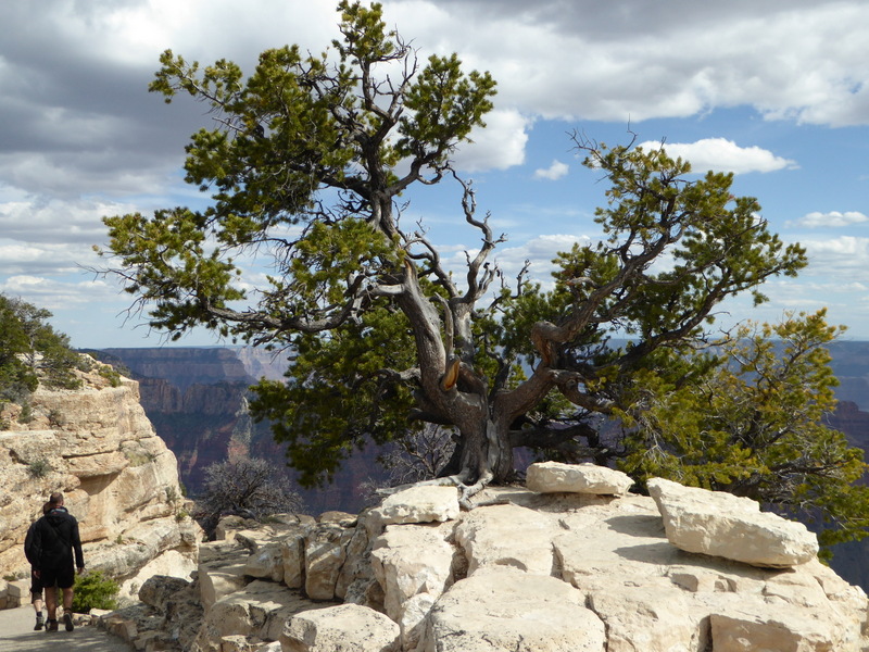
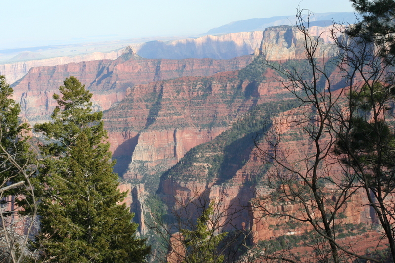
There are a number of trails in the area and most were 1.5 plus miles long and considered moderate to tough. Too bad we didn't come here 20 years ago and hike some of them. We did drive to three outlook points and enjoyed the views there a lot. The lookouts had better views of the Canyon than around the lodge and they weren't overrun with people.
Did I mention that it was windy at the outlooks? Well, it was so windy that I had to lean against a tree in order to hold the camera steady. That didn't stop Gerry from going all over and snapping pictures like crazy.
This was the highest point in the park that we were able to access without hiking a long distance. It was more than high enough for us and we could feel the thin air as we were breathing hard.
The high winds blew down a few trees on our way up to the lookout points. Two trees were covering a lane and would have caused some damage to the car if we had run over them. I sure wouldn't want to be trapped up there waiting for the Rangers to clear the road.
These stands of trees were beautiful with the sun glistening off of them. I couldn't get a good picture to really show off the beauty of the trees.
We saw this hawk eating some prey it had caught near the road. We stopped and took this picture and it didn't seem to be worried or concerned we were there.
It was getting late and we still had a 130 mile drive back to the rv park in Hurricane so we had to reluctantly start the trip back. It got a little hairy driving at dusk with all the deer alongside of the road. They blended in with the shrubs and foliage and were difficult to see. One panicked and ran right in front of us but I had slowed down and avoided it.
The ride back took a lot less time since we didn't sight see and just drove the speed limit. All in all we drove almost 300 miles in 10 hours and sure felt it when we got back home. It was worth it doing the drive this way rather than taking the motorhome down there and hoping to find a campsite.
We drove by Colorado City, Arizona on the way down to the North Rim and noticed a number of houses that looked like they were in various stages of being built. It looked strange but we thought they were only building when they had funds to do so. Evidently they have lower property taxes if the house is under construction so, the homes are never fully finished. For those who don't know anything about Colorado City it is the home of the FLDS group who believe in multiple wives for one man. They have been in the news lately for a number of their practices. I really don't know a lot about the group and can't say that much about them or their practices. A documentary was published today about the group.
FLDS Documentary
That was our day, how was yours?
After visiting the Pipe Spring Monument we got back on the road to the North Rim of the Grand Canyon. It was very windy on the road with a constant wind of 25-35mph with gusts higher than that. It sure did push our little car around. We still had a lot of miles to cover before we got there and made a beeline for the park. We did slow down enough to get a picture of a white tail squirrel in the Jacob Lake area. There were two of them running around so fast it was almost impossible to get a clear picture.
By the time we were in the Jacob Lake area it was mostly pine trees alongside of the road. We went through a forest fire burn area a few miles down the road. It lasted for miles. It's hard to imagine all those trees burning in that rough terrain and having to fight the fire. Not for me.
After driving many miles through the burn and then through a couple nice meadows we came to the entrance to the North Rim. We still had many miles to go to get to the North Rim Lodge. Since I had the Golden Age pass, we were able to not have to pay to enter the park. Nice!
We saw numerous herds of deer in the meadows and alongside of the road as we left. The herds were in groups of 5-15 deer and separated by a 1/2 mile or so. I guess they stake out their turf and stick to it.
Our first destination was the North Rim Lodge and a short hiking trail. The temperature had dropped to around 55 degrees and with the wind it was very cold. Gerry decided she wanted to take the hike and I thought better of it. She said it was beautiful but very difficult to be hiking at that altitude.
| Panorama taken near the North Rim Lodge |
The white spot, center, on the rim of the picture below is the lodge at the South Rim of the Grand Canyon. It was over 10 miles away and there was a lot of haze, but I managed to capture it with my 300mm camera lens.
![]() |
| North Rim Lodge |
| Photo spot |
We checked out the Lodge area and thought about having lunch there, but we were running late and the prices were quite high. It was a beautiful lodge from what we saw and would be nice to spend a few days there and just chill out.
There are a number of trails in the area and most were 1.5 plus miles long and considered moderate to tough. Too bad we didn't come here 20 years ago and hike some of them. We did drive to three outlook points and enjoyed the views there a lot. The lookouts had better views of the Canyon than around the lodge and they weren't overrun with people.
Did I mention that it was windy at the outlooks? Well, it was so windy that I had to lean against a tree in order to hold the camera steady. That didn't stop Gerry from going all over and snapping pictures like crazy.
This was the highest point in the park that we were able to access without hiking a long distance. It was more than high enough for us and we could feel the thin air as we were breathing hard.
The high winds blew down a few trees on our way up to the lookout points. Two trees were covering a lane and would have caused some damage to the car if we had run over them. I sure wouldn't want to be trapped up there waiting for the Rangers to clear the road.
These stands of trees were beautiful with the sun glistening off of them. I couldn't get a good picture to really show off the beauty of the trees.
We saw this hawk eating some prey it had caught near the road. We stopped and took this picture and it didn't seem to be worried or concerned we were there.
It was getting late and we still had a 130 mile drive back to the rv park in Hurricane so we had to reluctantly start the trip back. It got a little hairy driving at dusk with all the deer alongside of the road. They blended in with the shrubs and foliage and were difficult to see. One panicked and ran right in front of us but I had slowed down and avoided it.
The ride back took a lot less time since we didn't sight see and just drove the speed limit. All in all we drove almost 300 miles in 10 hours and sure felt it when we got back home. It was worth it doing the drive this way rather than taking the motorhome down there and hoping to find a campsite.
We drove by Colorado City, Arizona on the way down to the North Rim and noticed a number of houses that looked like they were in various stages of being built. It looked strange but we thought they were only building when they had funds to do so. Evidently they have lower property taxes if the house is under construction so, the homes are never fully finished. For those who don't know anything about Colorado City it is the home of the FLDS group who believe in multiple wives for one man. They have been in the news lately for a number of their practices. I really don't know a lot about the group and can't say that much about them or their practices. A documentary was published today about the group.
FLDS Documentary
That was our day, how was yours?
Sunday, May 22, 2016
Pipe Spring National Monument
May 20, 2016 Pipe Spring
Gerry and I had plans to drive to the North Rim of the Grand Canyon and I mapped out our route. As usual, I checked to see if there were any interesting geocaches along the way. I found a "virtual cache" at the Pipe Spring National Monument and it looked interesting so I downloaded it to my GPS.
In order to claim the cache we had to take the tour of the fort at Pipe Spring. It was one of the more interesting tours we have been to in a long time. A Ranger led us on the 1/2 hour tour and filled us in on the history of the fort/ranch house. He was very informative and answered all our questions but was stumped by one asked by a lady on the tour. She asked why the Indians gave up the spring and ponds since water was so important. He was a little perplexed and had to think about his answer. He finally said they didn't have a choice in the matter.
There is a natural spring that runs under the fort and into two small ponds. Rather than duplicate what Wikipedia has written about the fort, I am including a link to their interesting article on the fort.
Pipe_Spring_National_Monument
We managed to take a number of photos at the fort and could have taken many more. It was quite an interesting place with a lot of history to it.
Rather than trying to explain all about the Pipe Spring I am including a link to a virtual tour by the National Park Service. It is a well done tour and very informative. If you are ever in the Fredonia, AZ area I urge you to take the time to see the Monument. We both enjoyed the tour very much.
Virtual-tours-winsor-castle.htm
We continued on to the North Rim after the tour but including that part of the trip here will make the blog too long. North Rim will be included in my next blog.
Hope you enjoy the Pipe Spring information and virtual tour.
Gerry and I had plans to drive to the North Rim of the Grand Canyon and I mapped out our route. As usual, I checked to see if there were any interesting geocaches along the way. I found a "virtual cache" at the Pipe Spring National Monument and it looked interesting so I downloaded it to my GPS.
In order to claim the cache we had to take the tour of the fort at Pipe Spring. It was one of the more interesting tours we have been to in a long time. A Ranger led us on the 1/2 hour tour and filled us in on the history of the fort/ranch house. He was very informative and answered all our questions but was stumped by one asked by a lady on the tour. She asked why the Indians gave up the spring and ponds since water was so important. He was a little perplexed and had to think about his answer. He finally said they didn't have a choice in the matter.
There is a natural spring that runs under the fort and into two small ponds. Rather than duplicate what Wikipedia has written about the fort, I am including a link to their interesting article on the fort.
Pipe_Spring_National_Monument
We managed to take a number of photos at the fort and could have taken many more. It was quite an interesting place with a lot of history to it.
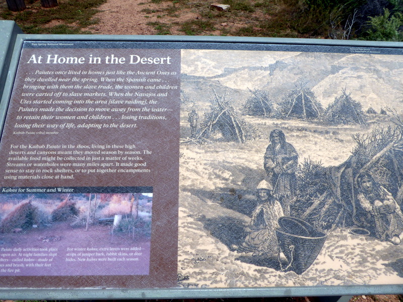
| Paiute temporary living area |
| Chuck Wagon |
| Winsor Castle Fort |
| First living quarters for early Mormon settlers |
| One of two sets of large doors in fort. |
| Kitchen/dining area |
| Family parlor with spring water running under the floor. |
| Dining table with chairs outward so prayers could be said kneeling |
| Spring water coming in |
Virtual-tours-winsor-castle.htm
We continued on to the North Rim after the tour but including that part of the trip here will make the blog too long. North Rim will be included in my next blog.
Hope you enjoy the Pipe Spring information and virtual tour.
Subscribe to:
Posts (Atom)